Enjoy the journey events

Enjoy the journey eventsEnjoy the journey eventsEnjoy the journey events
  • Home
  • Goat Rattler 100
  • GR100 Course Desc/Crew
  • Forked Up Trail Series
  • Coldwater In Your Veins
  • Goat Rattle 50 Miler
  • More
    • Home
    • Goat Rattler 100
    • GR100 Course Desc/Crew
    • Forked Up Trail Series
    • Coldwater In Your Veins
    • Goat Rattle 50 Miler

Enjoy the journey events

Enjoy the journey eventsEnjoy the journey eventsEnjoy the journey events
  • Home
  • Goat Rattler 100
  • GR100 Course Desc/Crew
  • Forked Up Trail Series
  • Coldwater In Your Veins
  • Goat Rattle 50 Miler

Goat Rattler 100

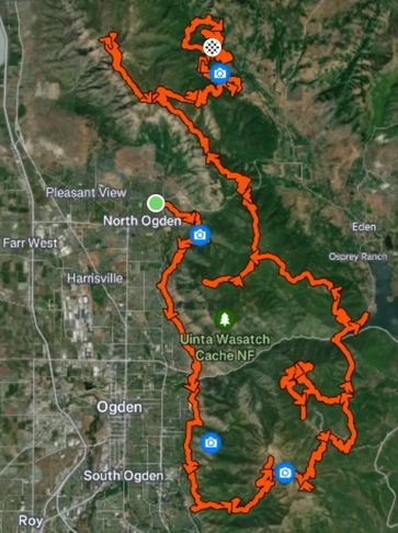
Map showing a hiking trail around Ogden and Uinta Wasatch Cache National Forest.

Course Profile/Description

There will be a course on Strava and CalTopo for you to review.  I'll have links to distances between aid stations and vert for you numbers enjoyment.  
Strava Course Detail
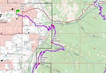
Map showing a hiking trail from Ogden to Divide with key viewpoints and water sources.

CalTopo Map

Another variation of course with detailed descriptions.  DOWNLOAD COURSE GPX FILE HERE:
CalTopo Map Details
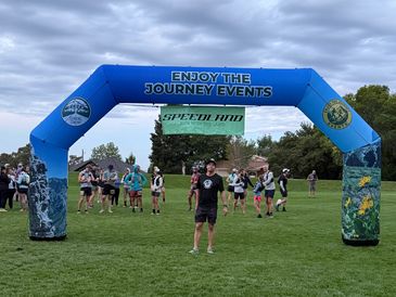
Runners gather under an arch for the Enjoy The Journey Speedland event.

Start in N. Ogden

Start in N. Ogden

Start will be at McGriff Park in North Ogden, will run on a combined asphalt and dirt road for 1.14 miles until you hit single track.  36 hour cutoff!

Crew sheet/aid station/cutoffs

Goat Rattler Crew Sheet (pdf)

Download

Goat Rattler Crew Sheet (xlsx)

Download

crewing/gps live tracking via garmin in-reach

AS1: Nature Center North Mile 7.55

AS2: Skyline/Weber State Mile 16.83

AS2: Skyline/Weber State Mile 16.83

Crews will be asked to hold at Mount Lewis Park on 1050 N and 925 E until runner is 10 min out.  Then park along N Mountain Rd and walk to aid station.

Start to AS1

AS2: Skyline/Weber State Mile 16.83

AS2: Skyline/Weber State Mile 16.83

AS2: Skyline/Weber State Mile 16.83

Large dirt parking lot above Weber State Stadium.  

AS1 to AS2

AS3: Needles Lodge mile 26.59

AS2: Skyline/Weber State Mile 16.83

AS4: Green Pond. Mile 36.71

Ride Gondola up for Free!

As2 to AS3

AS4: Green Pond. Mile 36.71

AS5: Lower Maples Mile 41.3

AS4: Green Pond. Mile 36.71

A popular trailhead outside of Snow Basin.  Plenty of parking along road.

AS3 to AS4

AS5: Lower Maples Mile 41.3

AS5: Lower Maples Mile 41.3

AS5: Lower Maples Mile 41.3

Lots of parking there. Pick up your first pacer here


AS4 to AS5

AS6: Ard Nord. Mile 51.2

AS5: Lower Maples Mile 41.3

AS5: Lower Maples Mile 41.3

Good parking in lot or along the road.

AS5 to AS6

AS7: Lewis Saddle Mile 61.55 & 66.17

AS7: Lewis Saddle Mile 61.55 & 66.17

AS7: Lewis Saddle Mile 61.55 & 66.17

No crew unless you wanna hike a while :)

AS6 to AS7

AS8: N. Ogden Divide. Mile 69.08

AS7: Lewis Saddle Mile 61.55 & 66.17

AS7: Lewis Saddle Mile 61.55 & 66.17

parking along road if lot is full 

AS7 to AS8

AS9: Ben Lomond Saddle. Mile 75.57

AS7: Lewis Saddle Mile 61.55 & 66.17

AS9: Ben Lomond Saddle. Mile 75.57

No Crew.  Really remote section.

AS8 to AS9

AS10: Willard Campground Mile 80.33

AS10: Willard Campground Mile 80.33

AS9: Ben Lomond Saddle. Mile 75.57


rough dirt road that requires 4x4 and high clearance vehicle

AS8 to AS9

AS11: Ben Lomond Saddle Mile 84.47

AS10: Willard Campground Mile 80.33

AS12: N Fork Coldwater Camp Mile 92

Retracing steps from Willard Campground to Ben Lomond Saddle.  You don't have to summit Willard and Benny again (unless you want to)

AS 10 to AS11

AS12: N Fork Coldwater Camp Mile 92

AS10: Willard Campground Mile 80.33

AS12: N Fork Coldwater Camp Mile 92

Big descent from Ben Lomond saddle down to N. Fork

AS 11 to AS12

AS 13: Mule Ear. Mile 95.27

AS 13: Mule Ear. Mile 95.27

AS 13: Mule Ear. Mile 95.27

This is the last aid station and not much parking.  You can park at Cutler Flats (Finish Line) and walk in from there (.48 mile walk).   

AS11 to AS 12

Finish Line. Mile 101.78

AS 13: Mule Ear. Mile 95.27

AS 13: Mule Ear. Mile 95.27

Plenty of parking here.  Please follow the parking attendant's directions.  

AS 12 to Finish

Drop Bags

Drop bags will be available at the following places: -Skyline/Weber St: (16.75) -Green Pond (36.7) -Lower Maples (41.38) -Ard Nord: (51.2) -N Ogden Divide (69.08) -Willard Campground (80.33) -N Fork Coldwater Camp (92) -Mule Ear (95.27)

Pacer Information

Pacers are allowed but not til Lower Maples Mile 41.38. This is a change from last year.

After Lower Maples, pacers can be swapped out at:

-Ard Nord: (51.2)

-N. Ogden Divide: (69.08)

-Willard Campground (80.33) long drive for crew on rough dirt road, not recommended

-North Fork Coldwater Camp: (92)

-Mule Ear: (95.27)


Pacers are under same rule obligations as crew.  Follow holding area/parking to not cause congestion at aid stations.  

101.78 miles with 21,600' vert 96% single track!

Course Profile

Delicious views from the course. . .

    Sponsors

    Ogden Running Company

    Contact Me

    Better yet, see us in person!

    You wanna chat in person?  Stop into the store and chat with the owner Jeremy.  You can send an email for more deets!

    1895 Washington Boulevard Suite 200, Ogden, Utah 84401, United States

    385-289-2900 jeremy@enjoythejourneyevents.com

    Send Message

    Attach Files
    Attachments (0)

    This site is protected by reCAPTCHA and the Google Privacy Policy and Terms of Service apply.

    Cancel

    Social

    Want to Volunteer?


    Copyright © 2026 Enjoy The Journey Events - All Rights Reserved.

    Powered by

    • GR100 Course Desc/Crew
    • Forked Up Trail Series
    • Coldwater In Your Veins
    • Goat Rattle 50 Miler

    This website uses cookies.

    We use cookies to analyze website traffic and optimize your website experience. By accepting our use of cookies, your data will be aggregated with all other user data.

    Accept